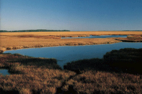
Low-lying areas near the Chesapeake Bay, like this marsh, could be dramatically affected by climate change.
Section 202(d) of Executive Order 13508 charges federal agencies to “ assess the impacts of a changing climate on the Chesapeake Bay and develop a strategy for adapting national resource programs and public infrastructure to the impacts of a changing climate in water quality and living resources of the Chesapeake Bay watershed .” An early draft report addressing this charge will be available to the public in September, with a revised draft released for public comment and engagement in November.
Although progress has been made in restoring and protecting the Chesapeake Bay ecosystem, the system remains degraded due to a long history of land clearing and development, fertilizer use, and human population increases. Climate change could add to these degraded conditions by negatively affecting water quality and quantity, public health, the sustainability of aquatic freshwater and marine and terrestrial living resources, and the quality of life and economic well-being of the watershed’s 17 million residents. Changes in climate patterns may significantly increase costs and timelines for restoring water quality and living resources. While there are some uncertainties around climate change projections, there is broad consensus that air and water temperatures are rising, sea-level rise is accelerating, and precipitation patterns will likely change in the Chesapeake Bay region.
Sea level in the Bay has risen approximately one foot over the last century, with slightly higher rates in the southern Bay—about twice the global average. According to a recent literature synthesis by the Chesapeake Bay Program’s Scientific and Technical Advisory Committee (STAC), by the year 2100, relative sea level is predicted to rise by two to five feet. This would adversely affect vital ecosystems that are important to sustain fisheries and other coastal-dependent jobs, improve water quality, and buffer the impacts from storms on upland habitats and property.
Many low-lying Chesapeake Bay communities, including large urban areas like Hampton Roads, the Washington, D.C., area, and Baltimore, are at risk from rising sea levels and increased storm surges. Flooding events threaten infrastructure, transportation, and water supplies, and can result in large economic losses.
Wetlands are also at risk. These habitats provide important ecological services, including serving as critical habitat for many fish, animals, and plants. They also improve water quality by filtering out sediment and pollutants, and protect adjacent upland areas from storm surge and erosion. Sea-level rise and wetland loss could increase shoreline erosion rates and lead to more turbid (muddy) shallow waters, which would make it difficult for underwater grasses to survive.
Higher-salinity ocean water will be driven into the Bay as sea levels rise. This may result in higher local salinities as seawater pushes farther into the Bay and rivers. Saltwater intrusion, whether by sea-level rise or storm surge, poses significant threats to water supplies, infrastructure, and wastewater treatment facilities along the Chesapeake Bay
Water temperatures are increasing as a result of climate change. According to the STAC report, by 2100 regional warming is projected to be 4-110 F above historical averages. Increased temperatures may increase the growing season of species such as oysters, but it may also increase the early onset of devastating oyster diseases that thrive in warmer temperatures and saltier waters. Harmful algal blooms should also increase in frequency and distribution as Bay waters warm
Temperature and salinity are major factors in determining species ranges; therefore, widespread changes to plant and animal distributions are expected. For example, if summer temperatures increase to even the conservative projections, cooler-water underwater grasses may no longer survive in the lower Chesapeake Bay, which would lead to significant declines in fish populations and water quality. And cooler-water fish species such as striped bass may be replaced by warmer-water species such as brown shrimp
More research is needed to understand how climate change will affect precipitation patterns and storm events. With sea levels higher, even equivalent storms the same strength as today’s storms will produce greater coastal inundation. Current models indicate winter and spring precipitation is likely to increase (potentially up to 10%), and storm intensity may also increase. Precipitation drives freshwater flow into the Chesapeake Bay estuary, which is a major factor in determining circulation patterns, as well as nutrient and sediment loads from the watershed.
No areas of our watershed or society are immune to climate change. Although inland areas are not directly vulnerable to sea-level rise, they will experience significant effects from temperature increases and changes to precipitation patterns. Many Bay region states have already begun to aggressively address climate change through mitigation and adaptation strategies. The federal government also has numerous existing resources to address and minimize impacts from climate change. The 202(d) report will recommend strategies for improved coordination and collaboration among federal, state, and local governments to protect Chesapeake Bay resources and communities.
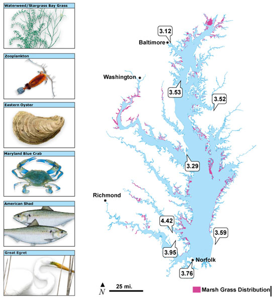
Fringe wetlands (pink areas) occur along the shorelines of much of the Chesapeake Bay and its tributaries. These areas provide valuable habitat for fish, birds, and a wide variety of other animals and plant. They also act to increase water quality and protect adjacent uplands from erosion and storm surge. As sea level rises, these fringe wetlands are increasingly threatened. The balloons on this map show the average relative rates of sea level rise (millimeters per year) for those locations, dating back to 1965 or earlier. (map adapted from EPA; sea level rise data from NOAA)
Where can I find more information?- The Intergovernmental Panel on Climate Change features a wealth of information on current predictions for climate change.
- NOAA, the federal agency charged with helping society understand, plan for, and respond to climate variability and change, shares information about climate change.
- USGS also runs programs associated with the Chesapeake Bay Program.